Back in 2013 I spent a short week along the north-east coast covering the area between the Forth estuary in Edinburgh and the Humber estuary in the East Riding of Yorkshire. In the intervening years I’ve spent more time in each area along that stretch, from Northumberland, through Newcastle, down the Durham Heritage Coast to Teesside and into North Yorkshire. My return to the East Riding has been a long time coming, but here we are…
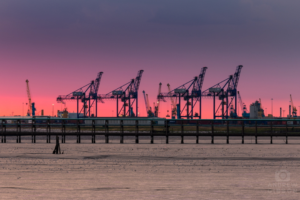
The picture at the top of this page is the Port of Humber, the dock cranes lining up like something from the War of the Worlds. The cloud cover was pretty thick, and this wasn’t the shot I had gone out for, but a thin strip of clear sky on the horizon gave a clue to the display that would be coming once the sun broke through, immediately prior to setting beneath the purple-tinted clouds. Nice though that was to watch I battled with lens flare as you might expect in those conditions, but the afterglow of pink under purple lent this image a quality I liked far more than I was expecting to. And it was a rare chance to get some use out of the long lens.
But it was the day after that I was most looking forward to, as I set out to explore the kind of desolate history-drenched location I enjoy: Spurn Point.
My recollections of Mr. Schofield’s A-Level geography lessons tell me that Spurn is a spit, a thin ridge of land that in this case protrudes three and a half miles out in to the Humber estuary and is susceptible to the aggressive tidal whims of the North Sea. It’s sand, shale and clay constituent parts are washed along the coast by the process of long shore drift and it is constantly and gradually extending further out in to the estuary as a result.
Shout out Mr. Schofield if you’re reading this (doubtful).
Last time I visited I drove all the way down the old military road and parked by the lighthouses at the end, but not long afterwards a vicious tempest breached the land mass and caused a catastrophic failure of the roadway a good half-mile long. Which means you now have to walk all the way there and back – 7 miles in the round and on a hot sunny Tuesday in August you’d be well advised to wear sunscreen. At the worst of times it’s now a tidal island so it’s also a good idea to check the tide tables…
")
It was a beautiful day and the kind of place where you hardly see anyone else. But there was a distinct lack of cloud to play with, and since I’m not really given to indulge in the latest ‘sky replacement’ fad you’ll have to make do with this shot as it actually appeared. It’s nice, but it could have been better…
Aside from two lighthouses (this shot depicts the “new” one, operational from 1895-1985) you’ll find an artillery bunker half-buried towards the end of the land mass, as well as the remains of military roads and railways. Spurn’s bunkers are now considerably lower down than would make them usable given that you can no longer see any maritime threats from them – a result of the shifting sands – but they are at least there and you can explore them. At the landward end however it’s a different story…
The sand and shale being washed along the coast has to come from somewhere else, and while Spurn is extending, elsewhere it’s retracting at an alarming rate. In the nearby village of Easington and in the shadow of a caravan site rather too close to the edge for comfort, the ruins of another military battery are strewn across the beach: Fort Godwin.

Godwin Battery was built in 1915 and remained in use beyond the Second World War, but by the 1990s some savage coastal erosion had resulted in chunks of it falling into the sea, as if the cliffs were purging it from within. These strange structures now litter the beach, with very little clinging on above. The great chunks of concrete evoke a sense of awe, another reminder of the power of the sea. And they make an interesting subject for some long-exposure seascape photography.

Gun emplacements sit tilted in the sea as the tide washes around them, while the strongpoint, aprons and other structures litter the beach like the set of an end-of-the-world post-apocalyptic thriller. Most of what hadn’t fallen over the edge has now been demolished to stop it doing so.

The thing about coastal erosion is that it will eventually reach some kind of equilibrium and stop. But nobody knows when that will happen, and in the meantime this section of the coast is at risk.
I was staying at Withernsea, a place famous for its castellated pier towers. The late Victorian pier itself only lasted a handful of years before being hit and damaged by so many passing ships it was simply written off as a bad loss. But there’s a plaque on the wall there pointing to the site of a medieval church – a mile out in to the ocean…